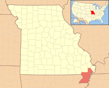
See, in 1811 there was a nasty earthquake on the eastern side of that red region. A lot of the folks there moved away, and a fellow by the name of John Walker bought up a lot of their land (probably for a song). Since it had the St. Francis River on the west and the Mississippi River on the east, irrigating it was about as easy as can be, and pretty soon Walker had a profitable estate.
Then there were rumblings about Missouri getting admitted as a state, and Walker heard about the line putting his land into Arkansas. He wasn't too happy about that, since Missouri had a lot more natural resources, with the rivers to boot. So he went and talked about the land that he owned having closer ties with the Mississippi River towns of Cape Girardeau, Ste. Genevieve and St. Louis in Missouri than with Arkansas, and Congress cut that notch there.
Oh, there's a story about people living in the bootheel who didn't want to live in Arkansas with its bears and panthers and copperhead snakes, and another about a surveyor who was in love with a Missouri widow who lived in the bootheel, but not much evidence for either. Not to say that those couldn't have been true owing to their silliness, because Walker's situation isn't a whole lot more sensible, but there you have it.
Facts herein are from How the States Got Their Shapes, Mark Stein, 2008, published by HarperCollins Publishers.
No comments:
Post a Comment